
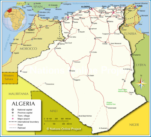
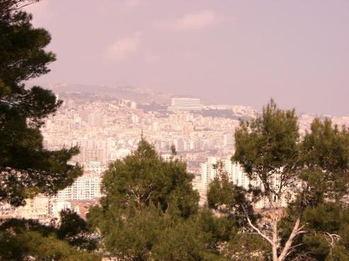
algeria in africa.
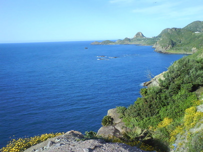
Algeria is the most beautiful countries in the world and in africa, enjoying the sea the great and beautiful in the north and the high plateaus in the interior, which has in the winter snowfall wonderful in the mountains and the interior is characterized by Algeria big desert vast and big, beautiful and area is the Hoggar of the most beautiful regions in the world and enjoy the Algerian Sahara warmest sunset sun in the world according to regional bodies and internsational.
Hoggar
The size of France, the Hoggar (Ahaggar or) emerged from the base Sahara following the violent eruptions of the Tertiary and Quaternary.
Occupying the center of the Hoggar Massif Atakor rises to almost 3,000 m with Tahat. It continues north into the mountains of Tefedest, including the famous El Garet Djenoun culminates at 2327 m; this huge set of beautiful granite houses cave sites (mainly around Mertoutek). At early times, huge rivers were leaving the castle of water to irrigate the Sahara. It remains a place of privileged life as the rain water is collected from the rocks and in sandy wadis: Wadi Tamanrasset is lost in the sands of Tanezrouft, Oued Tin Tarabin Rejoind east of Wadi Tafassaset to lead to Lake Chad.
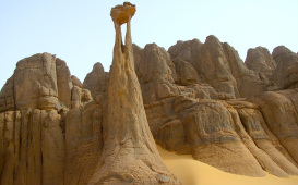
Hoggar this chaotic landscape consisting of peaks, towers, domes, spiers, pyramids, basalt, lava flows frozen in their movement, ... whose colors range from bright yellow to purple black. Everywhere large deep valleys between steep high walls.
Around this core, we find a set of sandstone plateaus: tassilis, where sand and rock are woven into the enchanting landscapes: the Immidir Ahnet and northwest, Missao Tin, Tin Rerhoh and the Tassili Hoggar south and finally the best known and largest n'Ajjer the northeast.
Northeast of the Hoggar, full of Amadror is a huge bowl to the bottom of which were deposited large amounts of salt which are the main wealth of the Tuaregs.
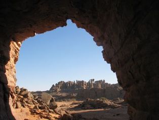
The Tassili N Ajjer.
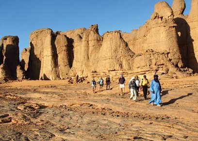
Located northeast of Atakor the tassili Ajjers (plateau rivers, Tamahaq) is a sandstone plateau of 350,000 km2 of sand that emerges from Algeria to Libya; sahauteur average is 600 m.
Around and inside the plateau is a series of sheer cliffs, carved into the sandstone gueltas, deep, narrow canyons alternating broad dark circuses and regs, the "Stone Forest" (the Tuareg irrekanes ). The sand accumulated at the foot of columns and arches introduce softness and sensuality in these silent immensities.
A "relic flora" of Mediterranean origin there remains: oleanders of Guelta of Essendilène, cypress Tamrit ...
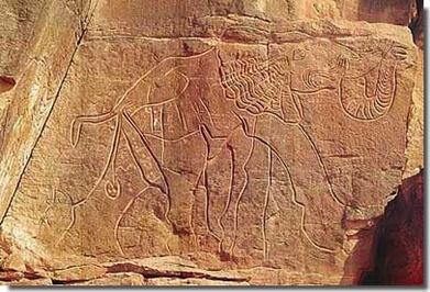
The Tassili N'Ajjer was made famous by Henri Lhote in the 50's who cataloged thousands of rock paintings and engravings. The temple of rock painting is undoubtedly the plateau Jabbaren, a site not particularly beautiful, arid and rocky, but contains nearly 5,000 paintings (departing from Djanet, 20 km to the foot of the plateau, then 15 km 'painful ascent).
The erg Admer arises at the center of N'Ajjer, to Essendilene and down south to join the great plain of Tafasset, which empties into the Ténéré in Niger.
Around and inside the plateau is a series of sheer cliffs, carved into the sandstone gueltas, deep, narrow canyons alternating broad dark circuses and regs, the "Stone Forest" (the Tuareg irrekanes ). The sand accumulated at the foot of columns and arches introduce softness and sensuality in these silent immensities.
A "relic flora" of Mediterranean origin there remains: oleanders of Guelta of Essendilène, cypress Tamrit ...
The Tassili N'Ajjer was made famous by Henri Lhote in the 50's who cataloged thousands of rock paintings and engravings. The temple of rock painting is undoubtedly the plateau Jabbaren, a site not particularly beautiful, arid and rocky, but contains nearly 5,000 paintings (departing from Djanet, 20 km to the foot of the plateau, then 15 km 'painful ascent).
The erg Admer arises at the center of N'Ajjer, to Essendilene and down south to join the great plain of Tafasset, which empties into the Ténéré in Niger.
Great kabylie
Great Kabylie is the territory that the ancient Kabyle named Tamawya Taqbaylit (or Tamawya), either the "Kabyle Federation." It is distinguished by its elevation of the Petite Kabylie, east, and Lower Kabylie, west, and extends from north to south, the Mediterranean coast to the crest of Djurdjura. Three mountain ranges occupy in the bulk:
north to the sea, and east, the high wooded hills of Kabylia maritimeN 5, which culminates at Mount Tamgout (1278 m), and Akfadou, which marks the beginning of the Petite Kabylie ;
south, the limestone range of Djurdjura overlooking northwest Draa El Mizan depression Ouadhia-south valley of the Oued-Sahel Soummam, and culminating in Lalla Khadija (Tamgut Aâlayen), highest summit of all Tell Atlas (2308 m) 16;
between the two, bordered to the north by the basin Sebaou, adjoining the southeast Djurdjura, deeply cut by numerous gorges, ancient mountain massif of the Agawa, the most densely populated, with eight hundred meters moyenne17, 18. This is where are Tizi-Ouzou (founded in colonial times and once called "the village", now the main town of Grande Kabylie) or Larbaâ Irathen Nath, the highest urban center in the region, about thousand feet.
The territory of Great Kabylia covers today the province of Tizi-Ouzou and a half that of Bouira, including centers Lakhdaria, Kadiria, Bouira Haizer, and Bechloul M'Chedallah and bounded by Aghbalou and Chorfa side the province of Bejaia. The terms "High Kabylie" or "Kabylia Djurdjura" are often used as synonyms for "Grande Kabylie," sometimes to refer more specifically the portion south of Sebaou
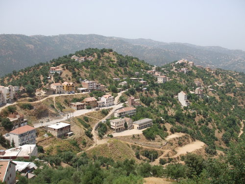
In Algeria, in the mountains of the Djurdjura, there is a cloud that hangs on relief.la Kabylie has three mountain ranges. The highest that of Djudjura literally "mountain of mountains" culminates at 2308 meters, the top of Mount Tamgout Aâlayen. Wedged between the Mediterranean and the Sahara, Kabylie is the weather amazing theater performances.
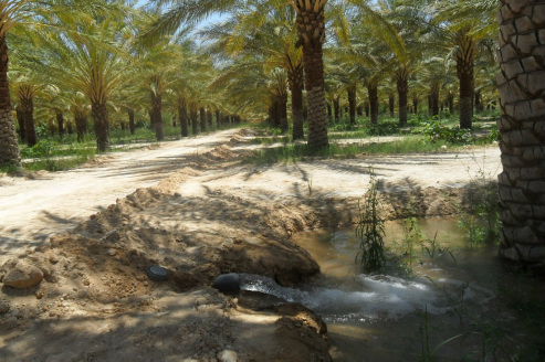
Sand, very soft in the Tassili Algeria a very beautiful place
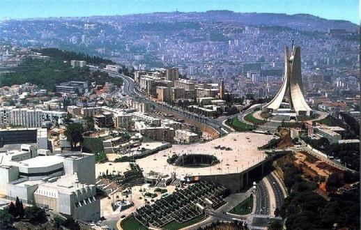
modern algeria Seeks the Algerian government to modernize Algeria and launch future projects and infrastructure development of the country's road network long road east - west of the great many ways to stretch of the desert, connecting north-south, large projects are other sports the largest stadiums in the eastern, central and west of the country because Algeria has huge potential and is seeking to modernize the country's long-medium and long term. In 2000 the Algerian government planned to raise and increase the number of tourists, while providing safety and security conditions improve and we are now in 2012 improved the number of tourists coming from different countries in the world.
Algeria is an Arabs country in North Africa which gained independence from France in 05/07/1962. Bordering the Mediterranean Sea, Morocco and Tunisia Between, Algeria is More Than Three Times the size of Texas. Along the Mediterranean Sea, between Morocco and Tunisia, Algeria is more than three times the size of Texas. Its name is Arabic for "the islands," and It Is Believed To Be a reference to the 998 kilometers of coastline beside the rocky islands of the Mediterranean. Its name in Arabic means "the islands", and it is considered a reference to 998 kilometers of coastline beside the rocky islands of the Mediterranean. The country is mostly high plateau and desert with Some mountains. The country is mostly high plateau and desert with some mountains. The Sahara desert covers 80 percent of the Entire Country. The Sahara desert covers 80 percent of the entire country. Natural resources include petroleum, natural gas, iron ore, phosphates, uranium, lead, and zinc. Natural resources are petroleum, natural gas, iron ore, phosphates, uranium, lead and zinc. Algeria Has the fifth-largest reserves of natural gas in the world, is the second Largest export gas, and ranks fourteenth for oil reserves. Algeria has the fifth largest reserves of natural gas in the world, is the largest exporter of gas in second place, and ranks fourteenth for oil reserves. Its population of 30 million Speaks Arabic, the official language, as well as French and Berber dialects. Its population of 30 million speak arabic, the official language, and other French and amazygh dialects. Algeria's ethnic mix is 99 percent Arab-Berber, with Less Than One percent European. Ethnic mix of Algeria is 99 percent Arab-Berber, less than one percent European. The term Berber is derived from the Greeks, Who Used It To Refer To The indigenous people of North Africa.
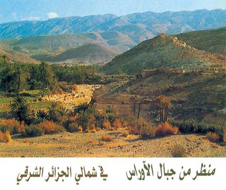
Auras Located in eastern Algeria and is characterized by a long series of mountain . the mountain of auras is big and nice it has a lot of "tffah" that meane apple and nice sun in summer .
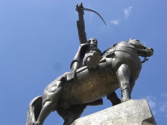
Abd el-Kader was the third son of Sidi Muhieddine, Sheikh of the Qadiri Sufi order and author of "Kitab al-Irshad muridin" aimed at novices in gnosis , and Zohra, an educated woman, daughter of Sheikh Sidi Boudouma, head of a zaouïa quite influential at the time located in Hammam Bouhadjar (western Algeria). He was probably born on May 6 or 6 September 1808 in El-Guetna ("Tents"), in the Mascara region, on the road to Oran.
According to French historians, the Emir Abd el-Kader traces its origins on the one hand to the Berber tribe of Banu Ifren (Zenetes). Furthermore, the Emir would be a descendant of the Prophet Muhammad. Abd al-Qadir ibn Muhyidin, Mostafa bin which is permanently installed in the plain of Ighriss, ibn Muhammad Qadi ibn Ahmed ibn Muhammad ibn Abdel-Cherkaoui, ibn Ali ibn Ahmed ibn Khaled ibn Yussef, ibn Ahmed ibn Bashar, Muhammed ibn, ibn Mas'ud, ibn Taus, ibn Yacoub, Abdelkaoui ibn, ibn Ahmed ibn Muhammad ibn Idriss II , ibn Idriss I, ibn Abdallah El Kamel Hassan ibn Al Muthana Hassan ibn Essabt, Fatima Zahra bint ibn Rassul Allah.
A precocious child, he could read and write at the age of 5 years, he was allowed to comment on the Quran and prophetic traditions to 12 years, and two years later, bore the title of "Hafeez," for those who know the Coran, in full, by heart.
Clearing of land for agricultural use and cutting of timber over the centuries have severely reduced the once bountiful forest wealth. Forest fires have also taken their toll. In the higher and wetter portions of the Tell Atlas, cork oak and Aleppo pine grow in thick soils. At lower levels on thinner soils, drought-resistant shrubs predominate. The grapevine is indigenous to the coastal lowlands, and grasses and scrub cover the High Plateaus. On the Saharan Atlas, little survives of the once extensive forests of Atlas cedar that have been exploited for fuel and timber since antiquity.
The forest reserves in Algeria were severely reduced during the colonial period. In 1967 it was calculated that the country's forested area extended over no more than 24,000 square kilometres of terrain, of which 18,000 km2 were overgrown with brushwood and scrub. By contrast, woodlands in 1830 had covered 50,000 km2. In the mid-1970s, however, the government embarked on a vast reforestation program to help control erosion, which was estimated to affect 100,000 cubic meters of arable land annually. Among projects was one to create a barrage vert (green barrier) more or less following the ridge line of the Saharan Atlas and extending from Morocco to the Tunisian frontier in a zone 1,500 kilometers long and up to twenty kilometers .
The barrage vert consists principally of Aleppo pine, a species that can thrive in areas of scanty rainfall. It is designed to restore a damaged ecological balance and to halt the northern encroachment of the Sahara. By the early 1980, the desert had already penetrated the hilly gap between the Saharan Atlas and the Auras Mountains as far as the town of Bou Saâda, a point well within the High Plateaus region. The barrage vert project was ended in the late 1980s because of lack of funds.
